
Showing posts with label Landslide. Show all posts
Showing posts with label Landslide. Show all posts
Tuesday, 3 January 2023
Mass Movement or Mass Wasting
Mass Movement or Mass Wasting 🌍🌐
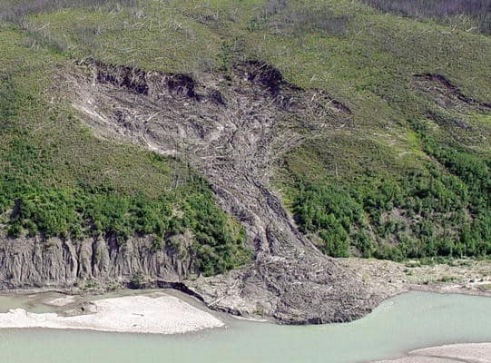
Mass movement also known as mass wasting is referred to the slow or rapid movement of weathered materials (rocks, sand, soil or mud) down the slope and mountain under the direct force of gravity. Mass movement can take place slowly, gradually or rapidly, hence affecting shallow to deep columns of materials depending on the gradient of the slope.
However, these movements transfer the mass of rock debris down the slopes under the direct influence of gravity. This means that air, water or ice dont usually transport debris along with them from place to place but on the other hand the debris may carry with it air, water or ice.
Gravity places its force on all materials, both bedrock and the products of weathering. However, weathering is not a necessity for mass movement though it aids mass movements. Mass movements are very effective on weathered slopes compared to unweathered materials.
 Mass movements are influenced by gravity and no geomorphic processes like running water, glaciers, wind, waves and currents contribute in the process of mass movements.
That means mass movements do not come under erosion though there is a shift (aided by gravity) of materials from one place to another. Materials on a sloppy hill have their own resistance to disturbing forces and will respond only when the force is greater than the shearing resistance of the materials.
Weak unconsolidated materials, faults, thinly bedded rocks, steeply dipping beds, abundant precipitation, vertical cliffs or steep slopes, and torrential rains and scarcity of vegetation for instance favour mass movements. Mass movement or mass wasting occurs on both terrestrial and submarine slope.
Credit: Razi Brown (Jotscrol.com)
#geosciencenetwork #geology #earthscience #geologist #landslide
Mass movements are influenced by gravity and no geomorphic processes like running water, glaciers, wind, waves and currents contribute in the process of mass movements.
That means mass movements do not come under erosion though there is a shift (aided by gravity) of materials from one place to another. Materials on a sloppy hill have their own resistance to disturbing forces and will respond only when the force is greater than the shearing resistance of the materials.
Weak unconsolidated materials, faults, thinly bedded rocks, steeply dipping beds, abundant precipitation, vertical cliffs or steep slopes, and torrential rains and scarcity of vegetation for instance favour mass movements. Mass movement or mass wasting occurs on both terrestrial and submarine slope.
Credit: Razi Brown (Jotscrol.com)
#geosciencenetwork #geology #earthscience #geologist #landslide
Monday, 16 November 2020
Handbook of Applied Spatial Analysis Software Tools, Methods and Applications

Preface
The Handbook is written for academics, researchers, practitioners and advanced graduate students. It has been designed to be read by those new or starting out in the field of spatial analysis as well as by those who are already familiar with the field.
The chapters have been written in such a way that readers who are new to the field will gain important overview and insight. At the same time, those readers who are already practitioners in the field will gain through the advanced and/or updated tools and new materials and state-of-the-art developments included.
Sunday, 27 January 2019
Advancing Culture of Living with Landslides -Volume 1
ISDR-ICL Sendai Partnerships
2015–2025
Kyoji Sassa • Matjaž Mikoš
Yueping Yin, Editors
Foreword
Landslides are a serious geological hazard. Among the host of natural triggers are intense
rainfall, flooding, earthquakes or volcanic eruption, and coastal erosion caused by storms that
are all too often tied to the El Niño phenomenon. Human triggers including deforestation,
irrigation or pipe leakage, and mining spoil piles, or stream and ocean current alteration can
also spark landslides.
Landslides occur worldwide but certain regions are particularly susceptible. The UN’s Food
and Agriculture Organization underlines that steep terrain, vulnerable soils, heavy rainfall, and
earthquake activity make large parts of Asia highly susceptible to landslides. Other hotspots
include Central, South, and Northwestern America.
Subscribe to:
Posts (Atom)

