

Showing posts with label Geology. Show all posts
Showing posts with label Geology. Show all posts
Tuesday, 3 January 2023
Beautiful Columnar Basalt, Symphony of the Stone, Yerevan, Armenia
Beautiful Columnar Basalt,
Symphony of the Stone, Yerevan, Armenia
Situated about 23 km east of Yerevan, Armenia, just below the village of the same name, lies the breathtaking Garni Gorge, with cliff walls of well-preserved basalt columns carved out by the Goght River on its sides. This part of the gorge is known as the “Symphony of the Stones,”. The columns suspended against gravity resemble an organ, which explains why the natural monument is also called the “Basalt Organ”. The soundtrack is provided by the river that flows through the gorge and fills the splendor of the stone with the symphony of water. The organ is made up of enormous symmetrical hexagonal and pentagonal basalt columns (almost 50 meters high), which appear to be handcrafted due to their extraordinary symmetry.
 These amazing rock formations were formed under high pressure conditions due to the cooling and crystallization of volcanic lava.The complex topography of Armenia was shaped by a geological upheaval that pushed up the Earth’s crust to form the Armenian Plateau 25 million years ago. How exactly the columnar jointing was formed is still uncertain, but it is usually explained by analogy with mud-cracks resulting from shrinkage at the surface of dried-up mud. The polygonal cracks in basalt are presumed to be due to contraction during cooling, which acts towards the creation of a series of equally spaced cooling centers. A tension crack is thought to form between two centers and since each center is surrounded by many others, a multi-sided polygonal crack system is formed, splitting the rock into roughly uniform polygonal blocks. As cooling proceeds towards the interior, cracks propagate inward at right angles to the cooling surface, resulting in the distinctive columnar structure.
#Geology #geology #geologyrocks #earthscience #geologist #geoscience #geosciencenetwork
Image credit: @globetolter[IG
These amazing rock formations were formed under high pressure conditions due to the cooling and crystallization of volcanic lava.The complex topography of Armenia was shaped by a geological upheaval that pushed up the Earth’s crust to form the Armenian Plateau 25 million years ago. How exactly the columnar jointing was formed is still uncertain, but it is usually explained by analogy with mud-cracks resulting from shrinkage at the surface of dried-up mud. The polygonal cracks in basalt are presumed to be due to contraction during cooling, which acts towards the creation of a series of equally spaced cooling centers. A tension crack is thought to form between two centers and since each center is surrounded by many others, a multi-sided polygonal crack system is formed, splitting the rock into roughly uniform polygonal blocks. As cooling proceeds towards the interior, cracks propagate inward at right angles to the cooling surface, resulting in the distinctive columnar structure.
#Geology #geology #geologyrocks #earthscience #geologist #geoscience #geosciencenetwork
Image credit: @globetolter[IG
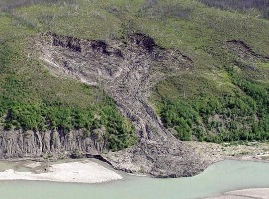
Mass Movement or Mass Wasting
Mass Movement or Mass Wasting 🌍🌐
Mass movement also known as mass wasting is referred to the slow or rapid movement of weathered materials (rocks, sand, soil or mud) down the slope and mountain under the direct force of gravity. Mass movement can take place slowly, gradually or rapidly, hence affecting shallow to deep columns of materials depending on the gradient of the slope.
However, these movements transfer the mass of rock debris down the slopes under the direct influence of gravity. This means that air, water or ice dont usually transport debris along with them from place to place but on the other hand the debris may carry with it air, water or ice.
Gravity places its force on all materials, both bedrock and the products of weathering. However, weathering is not a necessity for mass movement though it aids mass movements. Mass movements are very effective on weathered slopes compared to unweathered materials.
 Mass movements are influenced by gravity and no geomorphic processes like running water, glaciers, wind, waves and currents contribute in the process of mass movements.
That means mass movements do not come under erosion though there is a shift (aided by gravity) of materials from one place to another. Materials on a sloppy hill have their own resistance to disturbing forces and will respond only when the force is greater than the shearing resistance of the materials.
Weak unconsolidated materials, faults, thinly bedded rocks, steeply dipping beds, abundant precipitation, vertical cliffs or steep slopes, and torrential rains and scarcity of vegetation for instance favour mass movements. Mass movement or mass wasting occurs on both terrestrial and submarine slope.
Credit: Razi Brown (Jotscrol.com)
#geosciencenetwork #geology #earthscience #geologist #landslide
Mass movements are influenced by gravity and no geomorphic processes like running water, glaciers, wind, waves and currents contribute in the process of mass movements.
That means mass movements do not come under erosion though there is a shift (aided by gravity) of materials from one place to another. Materials on a sloppy hill have their own resistance to disturbing forces and will respond only when the force is greater than the shearing resistance of the materials.
Weak unconsolidated materials, faults, thinly bedded rocks, steeply dipping beds, abundant precipitation, vertical cliffs or steep slopes, and torrential rains and scarcity of vegetation for instance favour mass movements. Mass movement or mass wasting occurs on both terrestrial and submarine slope.
Credit: Razi Brown (Jotscrol.com)
#geosciencenetwork #geology #earthscience #geologist #landslide
Monday, 14 December 2020
Hydrological Cycle
Hydrological cycle is also known as the “water cycle”; it is the normal water recycling system on Earth . Due to solar radiation, water evaporates, generally from the sea, lakes, etc. Water also evaporates from plant leaves through the mechanism of transpiration. As the steam rises in the atmosphere, it is being cooled, condensed, and returned to the land and the sea as precipitation. Precipitation falls on the earth as surface water and shapes the surface, creating thus streams of water that result in lakes and rivers.
 |
| Fig-1 Hydrological Cycle |
A part of the water precipitating penetrates the ground and moves downward through the incisions, forming aquifers. Finally, a part of the surface and underground water leads to sea. During this trip, water is converted in all phases: gas, liquid, and solid. As mentioned above, water always changes states between liquid, vapor, and ice, with these processes happening in the blink of an eye and over millions of years. #geology #geologystudent #geologist #hydrology #hydrogeo #hydrogeology
 |
| Fig-2 Hydrological Cycle |
Sunday, 10 May 2020
Earth Materials- Introduction to Mineralogy and Petrology

Contents Description
Basic aspects of mineralogy must precede the coverage of petrology. This sequence is obvious from chapter headings. After a brief, general introduction in Chapter 1, minerals and rocks are broadly defined in Chapter 2. That is followed by three chapters that relate to various mineralogical aspects and concepts.
Saturday, 4 April 2020
Unconformity, Disconformities and Nonconformities in Structural Geology
What is Unconformity, Disconformities and Nonconformities in Structural Geology?
Unconformity
An unconformity is a contact between two rock units in which the upper unit is usually much younger than the lower unit . Unconformities are typically buried erosional surfaces that can represent a break in the geologic record of hundreds of millions of years or more .
For example, the contact between a 400-million-year-old sandstone that was deposited by a rising sea on a weathered bedrock surface that is 600 million years old is an unconformity that represents a time hiatus of 200 million years.
Thursday, 19 March 2020
Hillslope Hydrology and Stability
Landslides occur when hillslopes become mechanically unstable, because of meteorological and geologic processes, and pose a serious threat to human environments in their proximity. The mechanical balance within hillslopes is governed by two coupled physical processes: hydrologic or subsurface flow and stress.
Thursday, 26 December 2019
Petroleum Geoscience: From Sedimentary Environments to Rock Physics

Preface
Petroleum geology is not a well-defined academic subject. It includes many different aspects of the Earth sciences which are used in petroleum exploration and production. Nearly all types of insight can in some cases be useful in petroleum exploration,but there are some disciplines that are most relevant.
Sunday, 15 December 2019
Drawing Geological Structures

PREFACE
Drawing is not one of my strengths. My firs attempts at representing rock structures from the fiel on paper ended in disaster, both with regard to the graphic quality as well as the information content of the drawings. It took a long time for me to be able to draw structures halfway precisely and increase their recognition value; to use perspective; to learn to draw symbolically; and to compose larger outcrop drawings and block diagrams.
Thursday, 28 November 2019
Groundwater Hydrology Engineering, Planning and Management

Preface: The demand for freshwater is increasing as the world’s population continues to grow and expects higher standards of living.
Thursday, 12 September 2019
Fundamentals of Structural Geology, PDF eBook
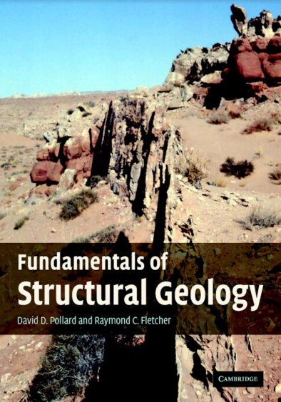 |
| Fundamentals of Structural Geology |
Download Link Given Below
Fundamentals of Structural Geology provides a new framework for the investigation of geological structures by integrating field mapping and mechanical analysis. It emphasizes the observational data, modern mapping technology, principles of continuum mechanics, and the mathematical and computational skills, necessary to map, describe, model, and explain deformation in the Earth’s lithosphere quantitatively.
Tuesday, 23 July 2019
eBook-Submarine Geomorphology

Contents
Introduction................................................. 1
Aaron Micallef, Sebastian Krastel and Alessandra Savini
Part I
Data and Methods in Submarine Geomorphology
Sidescan Sonar .............................................. 13
Ingo Klaucke
Multibeam Echosounders ...................................... 25
John E. Hughes Clarke
STRUCTURAL GEOLOGY An Introduction to Geometrical Techniques

Preface
The first steps in the study of geological structures are largely geometrical. This is true
in the historical development of our knowledge of such structures, in the initial stages of
any field investigation, and in the education of a structural geologist. This concern for
geometry includes the methods of describing and illustrating the form and orientation of
geological structures, and the solution of various dimensional aspects of these structures.
Wednesday, 17 July 2019
Urban Geology Process-Oriented Concepts for Adaptive and Integrated Resource Management

Preface
This book reflects the experience of the authors, working in a multidisciplinary team of specialists and scientists on urban geosciences including geology, hydro-geology, hydrogeophysics, river-ecology, and on research projects at the Basel University. Besides the academic activities, the Applied and Environmental Geology (AUG) is in charge of the geological survey of the Cantons of Basel-Stadt and Basel-Landschaft.
Sunday, 14 July 2019
GROUNDWATER QUANTITY AND QUALITY MANAGEMENT

Table of Contents
Acknowledgments ......................................................................... vii
Contributors ......................................................................... viii
1. Introduction ......................................................................... 1
Stewart W. Taylor
1.1 Groundwater Management 1
1.2 Purpose, Scope, and Organization of Book 3
1.3 Future Trends 6
1.4 References 8
2. Groundwater Hydrology ......................................................... 10
George F. Pinder
Saturday, 13 July 2019
Investigating The History of The Earth
 |
| Investigating The History of The Earth |
Introduction
Every day we walk across its surface, admiring its variety of plants, animals, and landscapes. Earth has taken billions of years to evolve into the planet we now inhabit. This volume examines this long history, from Earth’s origins in a cloud of gas and dust to its place as a planet teeming with life. It addresses questions that scientists have long debated: how, why, and when did Earth form and develop into this complex and intriguing planet?
Thursday, 11 July 2019
Introduction to Coastal Processes and Geomorphology

Preface
This book is designed primarily as a textbook for an upper-level undergraduate course in coastal processes and geomorphology and it stems from a fourth-year course that I have taught for twenty five years at the University of Guelph. Its primary objective is to provide students with a description
of processes acting to erode, transport and deposit sediments in the coastal zone, and of the factors that act in concert with these to produce the infinite variety of features that characterise marine and freshwater coasts around the world.
Sunday, 19 May 2019
Geochemical Anomaly and Mineral Prospectivity Mapping in GIS

In this volume John Carranza not only offers a comprehensive review of the current state-of-the-art of processing geochemical data, their integration with complementary geodata sets and multivariate data analysis using spatial statistics to create maps enhanced for mineral exploration, but also brings the Handbook series to something of a milestone. This marks the first volume in which the topic of an earlier volume (Vol. 2) is in effect revisited and updated; though the approach and format are – appropriately entirely fresh.
Tuesday, 12 March 2019
Groundwater Resource Evaluation
Resource Evaluation, Augmentation, Contamination,
Restoration, Modeling and Management
 techniques in the identification of potential boreholes in hard rock region.") |
| Ground Water |
Preface of the Book
Groundwater plays a major role in the livelihood of mankind by providing
water for drinking, irrigation and industrial purposes. The rapid population
growth in the last three decades all over the globe resulted in exploiting
more groundwater. The distribution of groundwater—both in space and time—
is more erratic as it depends on the subsurface geological and climatic
conditions. In many countries, the decline of water level indicates that the
resources are depleted very fast.
It is, therefore, necessary to assess the
available subsurface resource in a more judicious scientific manner and then
apply it for evolving optimal utilization purposes. There is an urgent need
to have a comprehensive book, which contains the entire spectrum of groundwater assessment and management aspects. I had seen many books, which
cover only the specific aspects on groundwater exploration, exploitation,
augmentation, pollution and remediation and mathematical modeling but not
many books on the integrated aspects of all. It was, therefore, planned to
bring a book, which covers the above said aspects by inviting specific topics
from various experts of the globe.
Wednesday, 6 March 2019
Book-Sedimentology and Stratigraphy
Introduction: Sedimentology and Stratigraphy
Sedimentology is the study of the processes of formation, transport and deposition of material that accumulates as sediment in continental and marine environments and eventually forms sedimentary rocks.
 |
| Sedimentology and Stratigraphy |
Stratigraphy is the study of rocks to determine the order and timing of events in Earth history: it provides the time frame that allows us to interpret sedimentary rocks in terms of dynamic evolving environments. The stratigraphic record of sedimentary rocks is the fundamental database for understanding the evolution of life, plate tectonics through time and global climate change.
Subscribe to:
Posts (Atom)

