
Showing posts with label Geomorphology. Show all posts
Showing posts with label Geomorphology. Show all posts
Tuesday, 3 January 2023
Mass Movement or Mass Wasting
Mass Movement or Mass Wasting 🌍🌐
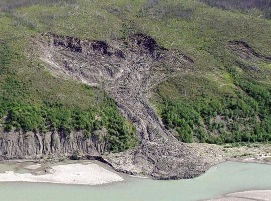
Mass movement also known as mass wasting is referred to the slow or rapid movement of weathered materials (rocks, sand, soil or mud) down the slope and mountain under the direct force of gravity. Mass movement can take place slowly, gradually or rapidly, hence affecting shallow to deep columns of materials depending on the gradient of the slope.
However, these movements transfer the mass of rock debris down the slopes under the direct influence of gravity. This means that air, water or ice dont usually transport debris along with them from place to place but on the other hand the debris may carry with it air, water or ice.
Gravity places its force on all materials, both bedrock and the products of weathering. However, weathering is not a necessity for mass movement though it aids mass movements. Mass movements are very effective on weathered slopes compared to unweathered materials.
 Mass movements are influenced by gravity and no geomorphic processes like running water, glaciers, wind, waves and currents contribute in the process of mass movements.
That means mass movements do not come under erosion though there is a shift (aided by gravity) of materials from one place to another. Materials on a sloppy hill have their own resistance to disturbing forces and will respond only when the force is greater than the shearing resistance of the materials.
Weak unconsolidated materials, faults, thinly bedded rocks, steeply dipping beds, abundant precipitation, vertical cliffs or steep slopes, and torrential rains and scarcity of vegetation for instance favour mass movements. Mass movement or mass wasting occurs on both terrestrial and submarine slope.
Credit: Razi Brown (Jotscrol.com)
#geosciencenetwork #geology #earthscience #geologist #landslide
Mass movements are influenced by gravity and no geomorphic processes like running water, glaciers, wind, waves and currents contribute in the process of mass movements.
That means mass movements do not come under erosion though there is a shift (aided by gravity) of materials from one place to another. Materials on a sloppy hill have their own resistance to disturbing forces and will respond only when the force is greater than the shearing resistance of the materials.
Weak unconsolidated materials, faults, thinly bedded rocks, steeply dipping beds, abundant precipitation, vertical cliffs or steep slopes, and torrential rains and scarcity of vegetation for instance favour mass movements. Mass movement or mass wasting occurs on both terrestrial and submarine slope.
Credit: Razi Brown (Jotscrol.com)
#geosciencenetwork #geology #earthscience #geologist #landslide

Tuesday, 23 July 2019
eBook-Submarine Geomorphology

Contents
Introduction................................................. 1
Aaron Micallef, Sebastian Krastel and Alessandra Savini
Part I
Data and Methods in Submarine Geomorphology
Sidescan Sonar .............................................. 13
Ingo Klaucke
Multibeam Echosounders ...................................... 25
John E. Hughes Clarke
Thursday, 11 July 2019
Introduction to Coastal Processes and Geomorphology

Preface
This book is designed primarily as a textbook for an upper-level undergraduate course in coastal processes and geomorphology and it stems from a fourth-year course that I have taught for twenty five years at the University of Guelph. Its primary objective is to provide students with a description
of processes acting to erode, transport and deposit sediments in the coastal zone, and of the factors that act in concert with these to produce the infinite variety of features that characterise marine and freshwater coasts around the world.
Subscribe to:
Posts (Atom)
Subscribe


 Posts
All Comments
Posts
All Comments