Georsgis Blog

↑ Grab this Headline Animator

Showing posts with label Article. Show all posts

Wednesday, 10 November 2021

e-PG Pathshala: platform for geo learners

    e-PG Pathshala is a formal initiation from the Ministry of Education, Government of India to disseminate knowledge through the use of ICTs which is under the  National Mission on Education through ICT (NME-ICT) executed by the University Grants Commission of India. With quality courses being the only requirement for the development of the education system, e-PG Pathshala hosts a number of courses, studying materials in the video formats to be watched by learners. All the learning materials come from university professors and working experts around the country.


    The other advantage is that the resources are online, freely available to anyone. This is

beneficial to students from other countries where similar learning initiatives are rarely available.

Even if such platforms are developed, there are a plethora of courses in rarer formats. For us,

learners of remote sensing, GIS and its applications, e-PG Pathshala is a boon in disguise.

PG stands for Post Graduate but it will assist any graduate, undergraduate, or any student or

learners alike. 


Anyone can check the site: https://epgp.inflibnet.ac.in/Home


    We have selected the following topics which are likely to interest remote sensing learners.

Since this blog is followed by geoscience enthusiasts, there are other courses that can be

helpful for them as well. 

The  course contains the 

(i) text material in pdf, 

(ii) presentation slides and 

(iii) video materials


    Some courses might be with all three materials while some with one or two materials.

The following lists are the selected subjects with the parts within them and 

the numbers within the brackets refer to the number of chapters.


    If you are only searching for remote sensing and GIS related materials there are mainly two

courses within the two main subjects highlighted among the lists. Go to the main page and search for the courses.


A. Subject: Risk / Disaster Management

P-01. Disaster risk mitigation: potential for microfinance (3)

P-02. Capacity development for risk/disaster management (10)

P-03. Economics of disaster (8)


B. Subject: Geology

P-02. Igneous and metamorphic petrology (GEL-02) (20)

P-03. Sedimentology & petroleum geology (GEL-03) (29)

P-04. Crystallography and mineralogy (GEL-04) (18)

P-05. Economic geology & mineral resources of India (GEL-05)

P-10. Hydrogeology & engineering geology (GEL-10)

P-11. Remote sensing and GIS (GEL-11) (33)


C. Subject: Earth Sciences

P-01. Earth mineral resources (2)

P-02. Geo-engineering & environmental systems (1)

P-03. Geohazards & disaster management (8)

P-04. Meteorology & climatology (2)

P-05. Oceanography (15)

P-06. The dynamic earth (6)

P-07. Sedimentology and Stratigraphy (12)

P-09. HYDROLOGY AND WATER RESOURCES (3)


D. Subject: Geography

P-01. Quantitative Technique (29)

P-03. Resource Geography (40)

P-06. Geographical thought (36)

P-08. Environmental Geography (33)

P-09. URBAN GEOGRAPHY (32)

P-10. Remote Sensing, GIS and GPS (35)

P-11. Geomorphology (35)

P-14. Climatology (38)

P-15. Geography of Natural Hazards and Disaster Management (35)

P-16. Geography of Water Resources (24)


E. Subject: Environmental Sciences

P-01. Ecosystem structures & functions (18)

P-02. Analytical chemistry (26)

P-03. Biodiversity and conservation (35)

P-04. Environmental geology (24)

P-05. Water resources and management (39)


P-06. Remote sensing & GIS applications in environmental science (40)

P-07. Energy and environment (40)

P-08. Atmospheric processes (40)

P-09. Environmental pollution -air & noise (8)

P-10. Environmental pollution - water & soil (39)

P-11. Solid and hazardous waste management (40)

P-12. Environmental management (34)

P-13. Environmental law and policies (40)

P-14. Statistical Applications in Environmental Sciences (34)

P-15. Environmental Microbiology & Biotechnology (37)

P-16. Environmental chemistry (36)


F. Subject: Computer Science

P-01.Data structures (40)

P-02.Computer architecture (40)

P-03.Operating system (40)

P-04.Database management system (39)

P-05.Design and analysis of algorithms (38)

P-06.Computer graphics and visualization (25)

P-07.Computer networks (38)

P-08.Software engineering (40)

P-09.Software quality management (40)

P-10.Compiler design (40)

P-11.Cryptography and network (40)

P-12.Web technology (40)

P-13.Embedded system (40)

P-14.Cloud computing (40)

P-15.Machine learning (39)

P-16.Data analytics (38)

P-17. Visualization techniques (16)


Hope this is new information for you and will help you in your learning journey. 


Monday, 14 December 2020

Hydrological Cycle


  Hydrological cycle is also known as the “water cycle”; it is the normal water recycling system on Earth . Due to solar radiation, water evaporates, generally from the sea, lakes, etc. Water also evaporates from plant leaves through the mechanism of transpiration. As the steam rises in the atmosphere, it is being cooled, condensed, and returned to the land and the sea as precipitation. Precipitation falls on the earth as surface water and shapes the surface, creating thus streams of water that result in lakes and rivers.

Fig-1 Hydrological Cycle


A part of the water precipitating penetrates the ground and moves downward through the incisions, forming aquifers. Finally, a part of the surface and underground water leads to sea. During this trip, water is converted in all phases: gas, liquid, and solid. As mentioned above, water always changes states between liquid, vapor, and ice, with these processes happening in the blink of an eye and over millions of years. #geology #geologystudent #geologist #hydrology #hydrogeo #hydrogeology

Fig-2 Hydrological Cycle


#watercycle #hydrologicalcycle

Friday, 10 April 2020

Normalized Difference Vegetation Index (NDVI)


Normalized Difference Vegetation Index (NDVI)


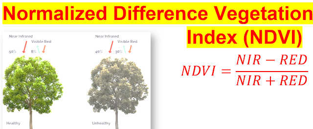
Normalized Difference Vegetation Index (NDVI) is used to quantify vegetation greenness and is useful in understanding vegetation density and assessing changes in plant health. NDVI is calculated as a ratio between the red (R) and near infrared (NIR) values in traditional fashion:


NDVI is calculated in accordance with the following 

generalized formula:


NDVI=(NIR-RED)/(NIR+RED)


Where NIR - reflection in the near-infrared spectrum and RED - reflection in the red range of the spectrum.


 NDVI Formula for

NDVI=(Band 4-Band 3)/(Band 4+Band 3)


Landsat 8,


NDVI=(Band 5-Band 4)/(Band 5+Band 4)


NDVI values range ​​from -1.0 to 1.0 representing greens, where negative values ​​are mainly formed from clouds, water and snow, and values ​​close to zero are primarily formed from rocks and bare soil. 

Very small values ​​(0.1 or less) of the NDVI function correspond to empty areas of rocks, sand or snow.

Moderate values ​​(from 0.2 to 0.3) represent shrubs and meadows, while large values ​​(from 0.6 to 0.8) indicate temperate and tropical forests.


NDVI is a measure of the state of plant health based on how the plant reflects light at certain frequencies (some waves are absorbed and others are reflected).


Saturday, 4 April 2020

Unconformity, Disconformities and Nonconformities in Structural Geology


What is Unconformity, Disconformities and Nonconformities in Structural Geology?


Unconformity


An unconformity is a contact between two rock units in which the upper unit is usually much younger than the lower unit . Unconformities are typically buried erosional surfaces that can represent a break in the geologic record of hundreds of millions of years or more . 


For example, the contact between a 400-million-year-old sandstone that was deposited by a rising sea on a weathered bedrock surface that is 600 million years old is an unconformity that represents a time hiatus of 200 million years. 

Monday, 9 March 2020

What is Remote Sensing


What is Remote Sensing?


"Remote detecting is the science (and somewhat, specialty) of gaining data about the Earth's surface without really being in contact with it. This is finished by detecting and recording reflected or transmitted Energy what's more, handling, breaking down, and applying that data."

Monday, 2 March 2020

Fault and Fault Terminology in Geology


What is Fault in Geology?


A fault is a fracture or region of fractures between two blocks of rock. Faults enable the blocks to pass relative to every other. This motion may appear rapidly, in the form of an earthquake - or may also happen slowly, in the shape of creep. 


Figure 1 Types of faulting in tectonic earthquakes,

Publisher
Encyclopædia Britannica, 2015


Faults may additionally vary in size from a few millimeters to thousands of kilometers. Most faults produce repeated displacements over geologic time. During an earthquake, the rock on one side of the fault suddenly slips with respect to the other. The fault surface can be horizontal or vertical or some arbitrary attitude in between.


Earth scientists use the angle of the fault with respect to the surface (known as the dip) and the direction of slip alongside the fault to classify faults. Faults which move along the direction of the dip airplane are dip-slip faults and described as either ordinary or reverse (thrust), depending on their motion. Faults which cross horizontally are regarded as strike-slip faults and are categorized as both right-lateral or left-lateral. Faults which exhibit each dip-slip and strike-slip action are recognized as oblique-slip faults.


Sunday, 1 March 2020

What is GIS? Component and Applications of GIS


What is GIS?


GIS, or geographic information systems, are computer-based equipment used to store, visualize, analyze, and interpret geographic data. Geographic data (also referred to as spatial, or geospatial data) identifies the geographic location of features.


These records consist of anything that can be associated with a region on the globe, or more in reality whatever that can be mapped. For example, roads, country boundaries, and tackle are all types of spatial data. 

A geographic Information system (GIS) lets in you to observe and explore everything about a place. 


Tuesday, 25 February 2020

Some Popular Geo Software With Video link


................................................


......................................................


..............................................


...............................................


...........................................
................................
......................................................
...................................
................................
...................................
.....................................
................................
.................................
...........................................

https://www.youtube.com/watch?v=6vxdRfpH3XE&t=60s

Contact us

Name

Email *

Message *

Follow us on Facebook and YouTube