

Tuesday, 3 January 2023
Beautiful Columnar Basalt, Symphony of the Stone, Yerevan, Armenia
Beautiful Columnar Basalt,
Symphony of the Stone, Yerevan, Armenia
Situated about 23 km east of Yerevan, Armenia, just below the village of the same name, lies the breathtaking Garni Gorge, with cliff walls of well-preserved basalt columns carved out by the Goght River on its sides. This part of the gorge is known as the “Symphony of the Stones,”. The columns suspended against gravity resemble an organ, which explains why the natural monument is also called the “Basalt Organ”. The soundtrack is provided by the river that flows through the gorge and fills the splendor of the stone with the symphony of water. The organ is made up of enormous symmetrical hexagonal and pentagonal basalt columns (almost 50 meters high), which appear to be handcrafted due to their extraordinary symmetry.
 These amazing rock formations were formed under high pressure conditions due to the cooling and crystallization of volcanic lava.The complex topography of Armenia was shaped by a geological upheaval that pushed up the Earth’s crust to form the Armenian Plateau 25 million years ago. How exactly the columnar jointing was formed is still uncertain, but it is usually explained by analogy with mud-cracks resulting from shrinkage at the surface of dried-up mud. The polygonal cracks in basalt are presumed to be due to contraction during cooling, which acts towards the creation of a series of equally spaced cooling centers. A tension crack is thought to form between two centers and since each center is surrounded by many others, a multi-sided polygonal crack system is formed, splitting the rock into roughly uniform polygonal blocks. As cooling proceeds towards the interior, cracks propagate inward at right angles to the cooling surface, resulting in the distinctive columnar structure.
#Geology #geology #geologyrocks #earthscience #geologist #geoscience #geosciencenetwork
Image credit: @globetolter[IG

Mass Movement or Mass Wasting
Mass Movement or Mass Wasting 🌍🌐
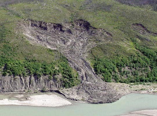
Mass movement also known as mass wasting is referred to the slow or rapid movement of weathered materials (rocks, sand, soil or mud) down the slope and mountain under the direct force of gravity. Mass movement can take place slowly, gradually or rapidly, hence affecting shallow to deep columns of materials depending on the gradient of the slope.
However, these movements transfer the mass of rock debris down the slopes under the direct influence of gravity. This means that air, water or ice dont usually transport debris along with them from place to place but on the other hand the debris may carry with it air, water or ice.
Gravity places its force on all materials, both bedrock and the products of weathering. However, weathering is not a necessity for mass movement though it aids mass movements. Mass movements are very effective on weathered slopes compared to unweathered materials.
 Mass movements are influenced by gravity and no geomorphic processes like running water, glaciers, wind, waves and currents contribute in the process of mass movements.
That means mass movements do not come under erosion though there is a shift (aided by gravity) of materials from one place to another. Materials on a sloppy hill have their own resistance to disturbing forces and will respond only when the force is greater than the shearing resistance of the materials.
Weak unconsolidated materials, faults, thinly bedded rocks, steeply dipping beds, abundant precipitation, vertical cliffs or steep slopes, and torrential rains and scarcity of vegetation for instance favour mass movements. Mass movement or mass wasting occurs on both terrestrial and submarine slope.
Credit: Razi Brown (Jotscrol.com)
#geosciencenetwork #geology #earthscience #geologist #landslide
Saturday, 18 December 2021
Tuesday, 14 December 2021
GEOTECHNICAL ENGINEERING pdf
PURPOSE AND SCOPE OF THE BOOK 'GEOTECHNICAL ENGINEERING'
There are not many books that cover both soil mechanics and foundation engineering which a student can use for his paper on Geotechnical Engineering. This paper is studied compulsorilyand available books, whatever few are there, have not been found satisfactory. Students are compelled to refer to three or four books to meet their requirements. The author has been prompted by the lack of a good comprehensive textbook to write this present work. He has made a sincere effort, to sum up, his experience of thirty-three years of teaching in the present book. The notable features of the book are as follows:
Saturday, 11 December 2021
Wednesday, 10 November 2021
e-PG Pathshala: platform for geo learners
e-PG Pathshala is a formal initiation from the Ministry of Education, Government of India to disseminate knowledge through the use of ICTs which is under the National Mission on Education through ICT (NME-ICT) executed by the University Grants Commission of India. With quality courses being the only requirement for the development of the education system, e-PG Pathshala hosts a number of courses, studying materials in the video formats to be watched by learners. All the learning materials come from university professors and working experts around the country.

The other advantage is that the resources are online, freely available to anyone. This is
beneficial to students from other countries where similar learning initiatives are rarely available.
Even if such platforms are developed, there are a plethora of courses in rarer formats. For us,
learners of remote sensing, GIS and its applications, e-PG Pathshala is a boon in disguise.
PG stands for Post Graduate but it will assist any graduate, undergraduate, or any student or
learners alike.
Anyone can check the site: https://epgp.inflibnet.ac.in/Home.
We have selected the following topics which are likely to interest remote sensing learners.
Since this blog is followed by geoscience enthusiasts, there are other courses that can be
helpful for them as well.
The course contains the
(i) text material in pdf,
(ii) presentation slides and
(iii) video materials
Some courses might be with all three materials while some with one or two materials.
The following lists are the selected subjects with the parts within them and
the numbers within the brackets refer to the number of chapters.
If you are only searching for remote sensing and GIS related materials there are mainly two
courses within the two main subjects highlighted among the lists. Go to the main page and search for the courses.
A. Subject: Risk / Disaster Management
P-01. Disaster risk mitigation: potential for microfinance (3)
P-02. Capacity development for risk/disaster management (10)
P-03. Economics of disaster (8)
B. Subject: Geology
P-02. Igneous and metamorphic petrology (GEL-02) (20)
P-03. Sedimentology & petroleum geology (GEL-03) (29)
P-04. Crystallography and mineralogy (GEL-04) (18)
P-05. Economic geology & mineral resources of India (GEL-05)
P-10. Hydrogeology & engineering geology (GEL-10)
P-11. Remote sensing and GIS (GEL-11) (33)
C. Subject: Earth Sciences
P-01. Earth mineral resources (2)
P-02. Geo-engineering & environmental systems (1)
P-03. Geohazards & disaster management (8)
P-04. Meteorology & climatology (2)
P-05. Oceanography (15)
P-06. The dynamic earth (6)
P-07. Sedimentology and Stratigraphy (12)
P-09. HYDROLOGY AND WATER RESOURCES (3)
D. Subject: Geography
P-01. Quantitative Technique (29)
P-03. Resource Geography (40)
P-06. Geographical thought (36)
P-08. Environmental Geography (33)
P-09. URBAN GEOGRAPHY (32)
P-10. Remote Sensing, GIS and GPS (35)
P-11. Geomorphology (35)
P-14. Climatology (38)
P-15. Geography of Natural Hazards and Disaster Management (35)
P-16. Geography of Water Resources (24)
E. Subject: Environmental Sciences
P-01. Ecosystem structures & functions (18)
P-02. Analytical chemistry (26)
P-03. Biodiversity and conservation (35)
P-04. Environmental geology (24)
P-05. Water resources and management (39)
P-06. Remote sensing & GIS applications in environmental science (40)
P-07. Energy and environment (40)
P-08. Atmospheric processes (40)
P-09. Environmental pollution -air & noise (8)
P-10. Environmental pollution - water & soil (39)
P-11. Solid and hazardous waste management (40)
P-12. Environmental management (34)
P-13. Environmental law and policies (40)
P-14. Statistical Applications in Environmental Sciences (34)
P-15. Environmental Microbiology & Biotechnology (37)
P-16. Environmental chemistry (36)
F. Subject: Computer Science
P-01.Data structures (40)
P-02.Computer architecture (40)
P-03.Operating system (40)
P-04.Database management system (39)
P-05.Design and analysis of algorithms (38)
P-06.Computer graphics and visualization (25)
P-07.Computer networks (38)
P-08.Software engineering (40)
P-09.Software quality management (40)
P-10.Compiler design (40)
P-11.Cryptography and network (40)
P-12.Web technology (40)
P-13.Embedded system (40)
P-14.Cloud computing (40)
P-15.Machine learning (39)
P-16.Data analytics (38)
P-17. Visualization techniques (16)
Hope this is new information for you and will help you in your learning journey.
Thursday, 4 November 2021
ESA SNAP WORKBOOK
ESA SNAP WORKBOOK
by Astri Polska
----------
from EO4EP – Earth Observation for Eastern Partnership
earth observation for sustainable development
Download Link: MergedFile (eo4sd-eastern.eu)
----------
This book is helpful for the beginner learners for SNAP sentinel toolbox.
Contains 5 chapters: first chapter deals with the installation guides; second, third and third chapter deals with basic raster tools within the software, optical and radar data processing respectively; and the final chapter with the automation of the process.
The book has only 46 pages making it very handy, crispy and easy to follow making it less bulkier. Although the major explanations of each step is lacking and real cases are not so fully provided, this is the reason this book presents the necessary steps for the early learners as a handy book. Definitely download for the early learners, or for others to revise and view it once.
----------
Download Link: MergedFile (eo4sd-eastern.eu)

Saturday, 11 September 2021
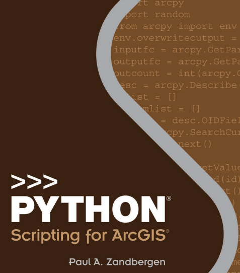
Python-Scripting-for-ArcGIS.pdf
Preface of the Book
The impetus for writing this book came from the lessons I’ve learned from using and teaching geographic information systems (GIS) for over 10 years at several different universities. One of these lessons is that “a little bit of code can go a long way.” Those of us who learned our first computer skills back in the days of MS-DOS became familiar with using a command prompt to carry out basic tasks. Early versions of ArcGIS for Desktop Advanced (ArcInfo) software also relied heavily on a command line interface, in addition to the use of the ARC Macro Language (AML).
Tuesday, 17 August 2021
Saturday, 31 July 2021
Thursday, 17 December 2020
Representing, Modeling and Visualizing the Natural Environment

Introduction to Representing, Modeling, and Visualizing the Natural Environment
Geographic information systems (GIS) provide a range of opportunities for exploring the complexity of the natural environment, offering tools and software packages that undergo continual innovation and development in response to new analytical demands for solutions to spatial problems. Geographic information science (GIScience) provides the academic framework for these technologies, addressing the theoretical and scientific issues associated with the use of GIS
.
Monday, 14 December 2020
Hydrological Cycle
Hydrological cycle is also known as the “water cycle”; it is the normal water recycling system on Earth . Due to solar radiation, water evaporates, generally from the sea, lakes, etc. Water also evaporates from plant leaves through the mechanism of transpiration. As the steam rises in the atmosphere, it is being cooled, condensed, and returned to the land and the sea as precipitation. Precipitation falls on the earth as surface water and shapes the surface, creating thus streams of water that result in lakes and rivers.
 |
| Fig-1 Hydrological Cycle |
A part of the water precipitating penetrates the ground and moves downward through the incisions, forming aquifers. Finally, a part of the surface and underground water leads to sea. During this trip, water is converted in all phases: gas, liquid, and solid. As mentioned above, water always changes states between liquid, vapor, and ice, with these processes happening in the blink of an eye and over millions of years. #geology #geologystudent #geologist #hydrology #hydrogeo #hydrogeology
 |
| Fig-2 Hydrological Cycle |
Monday, 16 November 2020
Handbook of Applied Spatial Analysis Software Tools, Methods and Applications

Preface
The Handbook is written for academics, researchers, practitioners and advanced graduate students. It has been designed to be read by those new or starting out in the field of spatial analysis as well as by those who are already familiar with the field.
The chapters have been written in such a way that readers who are new to the field will gain important overview and insight. At the same time, those readers who are already practitioners in the field will gain through the advanced and/or updated tools and new materials and state-of-the-art developments included.
Friday, 9 October 2020
Remote Sensing Image Fusion, pdf eBook
Preface of the Book

Nowadays, approximately four TB of image data are collected daily by instruments mounted on satellite platforms, not to mention the data produced by a myriad of specific campaigns carried out through airborne instruments. Very high-resolution (VHR) multispectral scanners, IKONOS, QuickBird, GeoEye,WorldView, Pl ́eiades, just to mention the most popular, and especially the related monospectral panchromatic instruments are responsible for a large part of the amount.
Thursday, 24 September 2020
Geospatial Tools for Urban Water Resources

Advances in the field of geospatial technologies have resulted in the growth in the application of such methods and techniques to a wider range of challenges and issues associated with urban water resources. The use of remote sensing, geographic information science (GIS), spatial analysis, global positioning systems (GPS),
digital mapping, online electronic data resources, and processing techniques are now common tools in addressing urban water quality, storm water, flooding, water supply issues, and overall management of water resources and watersheds in urban communities and urbanizing landscapes. In this volume, the authors address many of the complex concerns and impacts associated with human and natural changes
facing urban water resources through their use of a variety of geospatial techniques and tools. The aim of the volume is to present the reader a mix of examples of the evolving use of geospatial methods and applications now utilized in many urban areas to assist decision-makers, planners, and communities in making sound judgments as to how best manage their water resources for both human use and to minimize impacts to the natural environment.
Sunday, 6 September 2020
Mastering ArcGIS Pro

A new text for a new GIS experience
Although the concepts of GIS have remained fairly constant over time, the software is continually
evolving. With the release of ArcGIS Pro, the latest software in the Esri GIS family, a new generation of GIS has arrived. ArcGIS Pro has a 64-bit, multithreaded architecture, uses ribbon-style menus, integrates 2D and 3D applications, and is closely tied to ArcGIS Online.
Sunday, 10 May 2020
Earth Materials- Introduction to Mineralogy and Petrology

Contents Description
Basic aspects of mineralogy must precede the coverage of petrology. This sequence is obvious from chapter headings. After a brief, general introduction in Chapter 1, minerals and rocks are broadly defined in Chapter 2. That is followed by three chapters that relate to various mineralogical aspects and concepts.
Wednesday, 6 May 2020
Subscribe to:
Posts (Atom)
Subscribe


 Posts
All Comments