Georsgis Blog

↑ Grab this Headline Animator

Friday, 10 April 2020

Normalized Difference Vegetation Index (NDVI)


Normalized Difference Vegetation Index (NDVI)


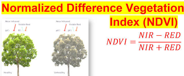
Normalized Difference Vegetation Index (NDVI) is used to quantify vegetation greenness and is useful in understanding vegetation density and assessing changes in plant health. NDVI is calculated as a ratio between the red (R) and near infrared (NIR) values in traditional fashion:


NDVI is calculated in accordance with the following 

generalized formula:


NDVI=(NIR-RED)/(NIR+RED)


Where NIR - reflection in the near-infrared spectrum and RED - reflection in the red range of the spectrum.


 NDVI Formula for

NDVI=(Band 4-Band 3)/(Band 4+Band 3)


Landsat 8,


NDVI=(Band 5-Band 4)/(Band 5+Band 4)


NDVI values range ​​from -1.0 to 1.0 representing greens, where negative values ​​are mainly formed from clouds, water and snow, and values ​​close to zero are primarily formed from rocks and bare soil. 

Very small values ​​(0.1 or less) of the NDVI function correspond to empty areas of rocks, sand or snow.

Moderate values ​​(from 0.2 to 0.3) represent shrubs and meadows, while large values ​​(from 0.6 to 0.8) indicate temperate and tropical forests.


NDVI is a measure of the state of plant health based on how the plant reflects light at certain frequencies (some waves are absorbed and others are reflected).


Wednesday, 8 April 2020

Spatial Analysis in Epidemiology


Preface of the Book


This book aims to provide a practical introduction to spatial analysis, by focusing on application rather than theory, and by drawing on a wide range of examples from both human and animal health, including vector-borne and infectious diseases and non-infectious conditions. This book provide worked examples of the principal methodologies, using mainly the same disease data set throughout, which allows for direct comparison of the various techniques and helps to demonstrate their comparative strengths and weaknesses.


Saturday, 4 April 2020

Unconformity, Disconformities and Nonconformities in Structural Geology


What is Unconformity, Disconformities and Nonconformities in Structural Geology?


Unconformity


An unconformity is a contact between two rock units in which the upper unit is usually much younger than the lower unit . Unconformities are typically buried erosional surfaces that can represent a break in the geologic record of hundreds of millions of years or more . 


For example, the contact between a 400-million-year-old sandstone that was deposited by a rising sea on a weathered bedrock surface that is 600 million years old is an unconformity that represents a time hiatus of 200 million years. 

Wednesday, 1 April 2020

WETLAND AND WATER RESOURCE MODELING AND ASSESSMENT A Watershed Perspective


WETLAND  AND WATER RESOURCE MODELING  AND  ASSESSMENT A Watershed Perspective


Preface: Toward a Watershed Perspective


This is a book about the methods and geospatial techniques for modeling and assessing wetlands and water resources at the watershed scale.The theme of the book, wetland and water resource modeling and assessment, is an active field of research that constantly undergoes theoretical and technical innovations. This book emphasizes a watershed perspective in the modeling and assessment areas. 


Contact us

Name

Email *

Message *

Follow us on Facebook and YouTube